About the Mesabi Trail
Traveling across the Iron Range of northeast Minnesota, the Mesabi Trail stretches from the Mississippi River in Grand Rapids, to the Boundary Waters Canoe Area Wilderness near Ely – with a few small gaps to be completed.
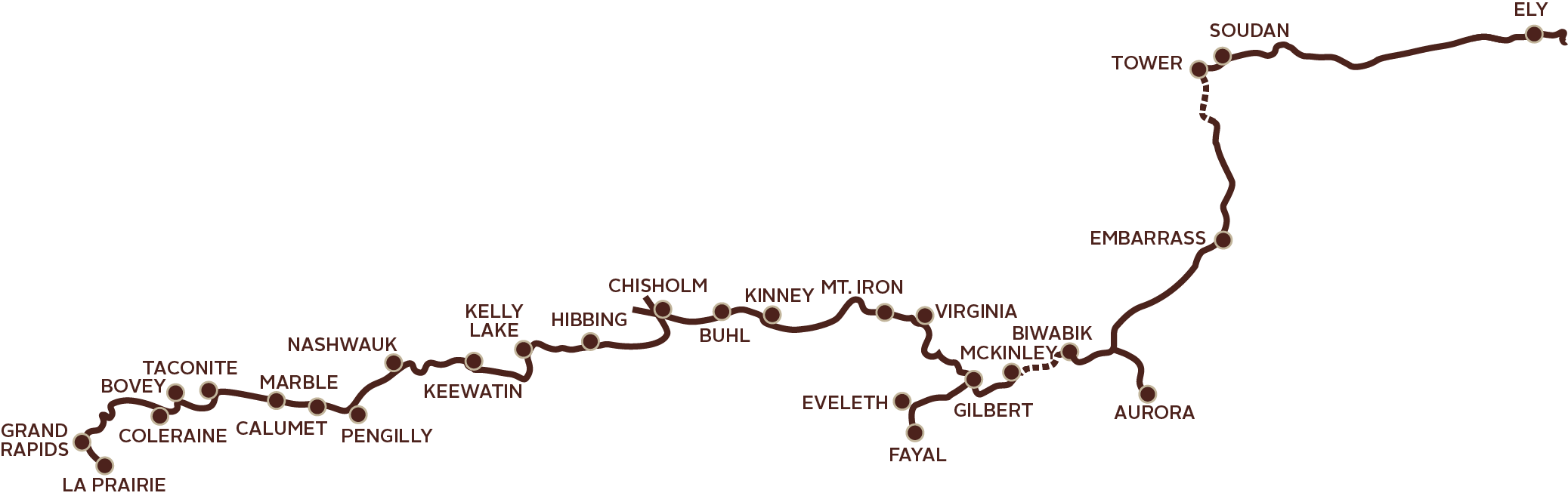
Currently over 160+ miles are finished, making the Mesabi Trail one of the longest paved bike trails in Minnesota. When totally complete (in 1-2 years), it will traverse almost 165 miles, four trail segments, plus a variety of spurs to link 28 communities. There are just two sections remaining.
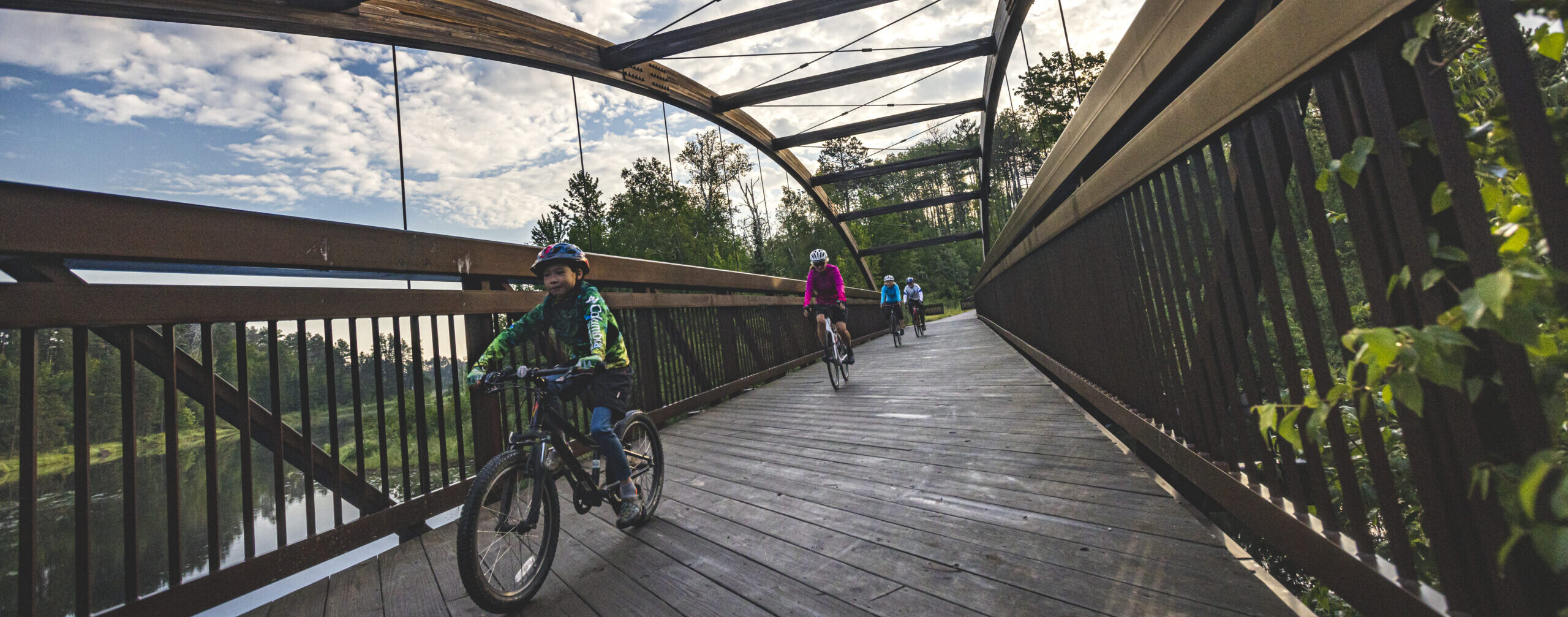
Visitors to the trail will find an 8 to 10 foot wide bituminous surface (asphalt paving) built on a combination of old railroad beds, abandoned highway grades, old logging and mining roads, and blazing trail through the forest to get the next community.
The Mesabi Trail is NOT simply a rail-to-trail conversion – it is not flat & straight. The terrain varies from hilly to flat over the entire length. A few hills will test your stamina going up, and your brakes going down – none are greater than an 8% grade – but some are fairly long.
Some sections of the trail are groomed in winter by communities nearby. They may be cleared for walking or groomed for snowmobiling, snowshoeing, or cross country skiing.
Download our trail map and check out the bottom for an elevation chart.
A wheel pass is required for anyone 18 or older using wheels on the trail.
Learn More Buy a wheel pass now
Current Trail Status
The Mesabi Trail is still under construction in two areas; and occasional detours and closures occur that are beyond our control – check Trail Updates & Conditions for current status.
The trail is always accessible, but the best conditions for cycling a paved bike trail in Minnesota are usually from sometime in April through mid October. Weather in Minnesota is always unpredictable – late or early snow can shorten or lengthen the season. Portions of the trail are in heavily wooded areas; we do not advise riding until all the snow & ice have melted in the spring and our trail staff has had a chance to clear away winter debris. Keep an eye on Trail Updates & Conditions, we’ll let you know when it’s ready for riding.
Please be patient in early spring. Our crews start ramping up in late April or early May clearing winter debris and gravel, but 160+ miles of trail is a long distance for only one or two crew members to clean up. We have full maintenance crews in place by June. We try to have cleared trail conditions for safe riding as quickly as we can.
If you are interested in helping clean up a trail section in the spring, let us know! We welcome and encourage volunteering!
By the end of 2025, the Mesabi Trail should be short just one connection leading into Tower – making it one of the longest, most scenic paved bike trails in Minnesota
GRAND RAPIDS TO MCKINLEY
The longest continuous stretch of 79 miles runs from Grand Rapids to McKinley. This section offers multiple spurs, including to the Minnesota Discovery Center and the Redhead Mountain Bike Park in Chisholm, and another from Gilbert to the Mesabi Station Trailhead in Eveleth, and on to Fayal Township. One of the many spectacular features along this section is crossing the Representative Thomas Rukavina Memorial Bridge just outside of Virginia. The Mesabi Trail takes up 14 feet of one side of the tallest bridge in Minnesota…the view is incredible!
BUHL TO KINNEY
The trail segment east of Buh, which is on Whiteside Road has been milled 0.3 miles. It will be rough gravel for that part. There are Caution signs up, so please be aware. This section recently received funding and is entering the design phase. Construction will hopefully begin this fall.
MCKINLEY TO BIWABIK
This section will be finished by June 2025 due to floating bridge installation having to occur in the winter.
BIWABIK THRU EMBARRASS TO KUGLER TOWNSHIP
Pick up the trail again outside of Biwabik and bike the next completed segment which stretches approximately 22 miles through the Giants Ridge Recreation Area & lift service mountain bike park, continuing 9.5 miles past Embarrass to Hwy 26 / Wahlsten Road in Kugler Township. There is also an additional 5.85-mile spur into Aurora. This section of the trail is not to be missed, running along the continental divide – it’s another spectacular view – topped off with a ride across a 3/4-mile-long floating bridge crossing the Embarrass Wetland Complex and the Darwin Meyers Wildlife Management Area. This floating bridge is truly one of a kind, and built right in Embarrass! Just a little heads up…there are a lot of hills on this section, and it might be a bit challenging for kids or inexperienced riders – build up your stamina and take this section on a little later in the season.
DARWIN MEYERS WILDLIFE MANAGEMENT AREA
The DNR will be doing some construction projects to repair dikes in the DMWMA. The work is just beginning, so don’t be surprised to see heavy equipment in the area. The Mesabi Trail will be open. Please use caution and pay attention to any equipment in the area.
KUGLER TOWNSHIP TO TOWER
The trail ends in Kugler Township – leaving a gap of about 6.8 miles short of Tower. There is no advisable connection to Tower – Hwy 135 may look like a good route, but it is a two lane rural highway with NO USABLE SHOULDER. Construction has begun on 4.5 miles of this section. We anticipate the trail finished to the West Two River. The remaining 2.5 miles into Tower is in design phase with construction anticipated in early spring of 2026. Check back in for updates.
TOWER THRU EAGLES NEST TO ELY
Pick up the trail again in Tower near the train museum. The next stretch will take you through Tower/Soudan and into the Lake Vermilion Soudan Underground Mine State Park (complete with a State campground). After touring through the state park, the trail heads toward the Eagles Nest Township where the route follows an absolutely gorgeous 11 mile stretch passing several lakes, streams, and ponds – taking you right into Ely.
ELY
Once you get to Ely, you are at the door step of the Boundary Waters Canoe Area Wilderness, one of the premier wilderness areas in the country. There is also connectivity to other trails – including the 3.8 mile long Trezona Trail around Miner’s Lake, and the road leading to the Hidden Valley Mountain Biking area. Reward yourself with a stay at any of the area’s accommodations, enjoy exploring Ely’s downtown, and visit some of the local attractions like the International Wolf Center, the North American Bear Center, and the Dorothy Molter Museum.
2025 CONSTRUCTION PLANS (Only two more sections remaining!)
- Last ¾ mile from the floating bridge to the kiosk in Biwabik complete by June 2025
- 5 miles from Benson Road to West Two River bridge in Kugler Township to be done by the end of summer 2025
- 2.5 miles from West Two River into Tower anticipated completion date end of summer 2026
- 5+ miles from Aurora to Hoyt Lakes to be completed by the end of summer 2026